Solutions by typeInfrastructure integrity
Who looks at the slope between one inspection and the next?
A slope warns slowly, and nobody watches slowly
Nine forty, a clear morning over the tailings pond. The basin is nearly full and the mud comes up close to the crest. Water is seeping out halfway down the outer slope and running away, cutting a gully between the earth and the stone. Yesterday that gully was a thread. Nobody knows that for certain, because nobody has yesterday’s photograph taken from the same spot with the same framing to hold up beside it.
9 cameras across 5 sectors
What IRIS is
IRIS watches the cameras for you.
IRIS Neural is an artificial intelligence that watches the cameras you already have and understands what happens in front of them. When something important happens —or something you told it you need to keep an eye on—, it alerts you; and whatever can be counted, it counts in numbers. All day long, without anyone having to watch a screen.
You tell it what you need to watch, and IRIS does it.
Works with the cameras you already have. Nothing to replace.
A person replies, not a form.
- Your footage never leaves your premises.
- It doesn't identify people.
- Certifications →
This is how you ask for it
«Tell me if water appears on the outer slope, if the gully grows or if the mud creeps towards the crest, and show me yesterday’s image beside it.»
By the time a slope really moves, there is no margin left. The material comes down onto the haul road, onto the next lane or onto the working floor, and at that point the only thing left to do is count who was underneath. Before that there were weeks of warnings: a damp patch, a gully that grows a hand’s width, a crest that has lost its line. They are all in photographs somebody took, filed in different folders and never once placed side by side.
You decide once
You decide this once. You say which slopes are watched, where the crest line sits in the image, how much something has to change before it counts, how often the comparison runs and who gets told: if water appears on the outer slope or the gully widens against last week, alert the person responsible for the pond with both images. IRIS checks it every day, including the days with no inspection scheduled, and above all through the fortnight when the team is busy elsewhere.
A slope almost never fails all at once. It fails after warning for days in a language nobody reads: a damp patch halfway down, a gully widening by a hand’s width, a crest that has lost its straight line, a bulge where there used to be a plane. The problem is not missing information. The problem is that seeing it requires yesterday’s photograph, taken from the same place with the same framing, and nobody has that photograph.
And this is not only mining. At twenty past six in the evening, a stack of recycling bales standing well above the wall and starting to come down onto the tipping floor. A slurry pond on an urban site, a hand’s width from the rim, yellow railings alongside. A road cutting that has shed earth and stone across the right-hand lane while a car approaches that has not seen it yet. They are all the same sentence: today this is not how it was.
IRIS keeps the framing still and compares the scene with itself. When something departs from what it was — water where there was none, material that has moved, a stack over the height of the wall, mud creeping towards the crest — it says so and shows both images together, today’s and the earlier one. It does not measure the millimetre and it does not predict the failure: it puts the change nobody had time to compare in front of the right person.
What changes
Before, there was an inspection every so often and a folder of photographs taken from roughly similar spots, impossible to line up against each other. Between two inspections, the slope was on its own. Now the same camera watches the same frame every day, and when something changes the comparison arrives already made: today’s image, the earlier one and the area marked. The walk-round does not disappear; it arrives knowing where to look first.
Where we have seen it
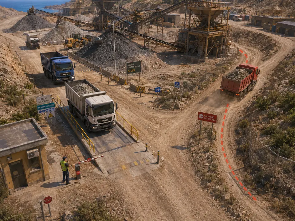
CAM-380A loaded truck leaves by a way that is not a way out
«Tell me if a loaded truck leaves the stockpile by the lower track instead of going over the weighbridge.»
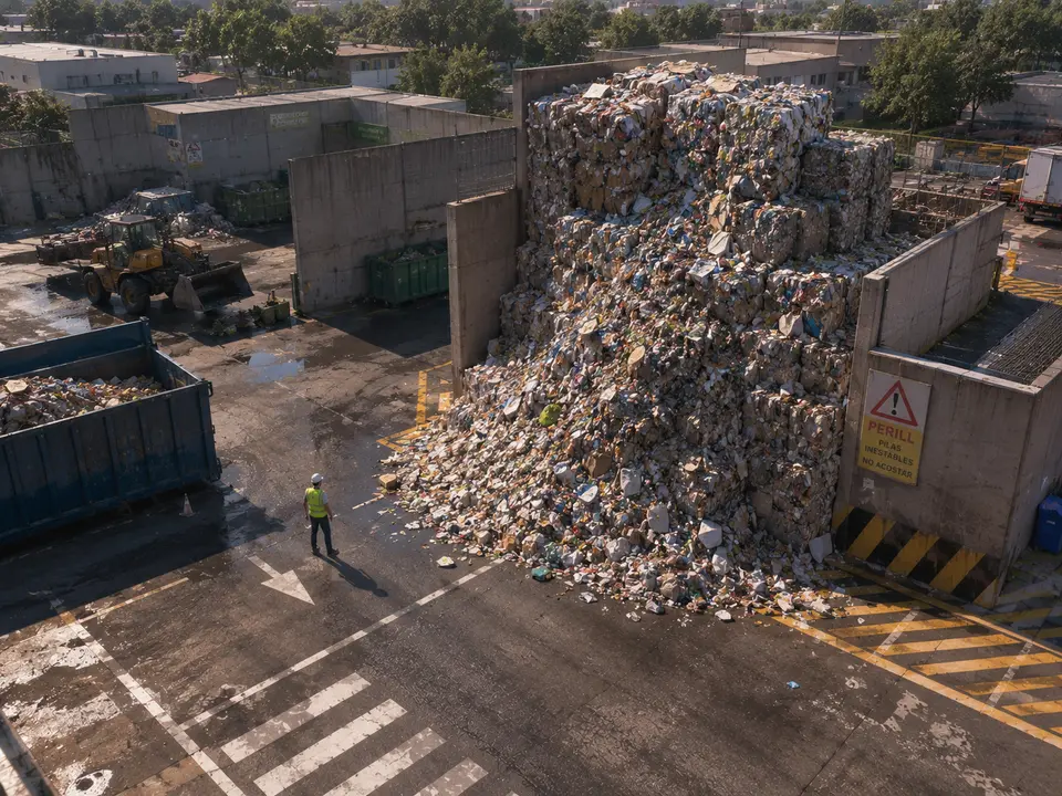
CAM-433The bale stack has slid onto the yard
«Tell me if a stack goes above the wall or if material slides onto the yard.»
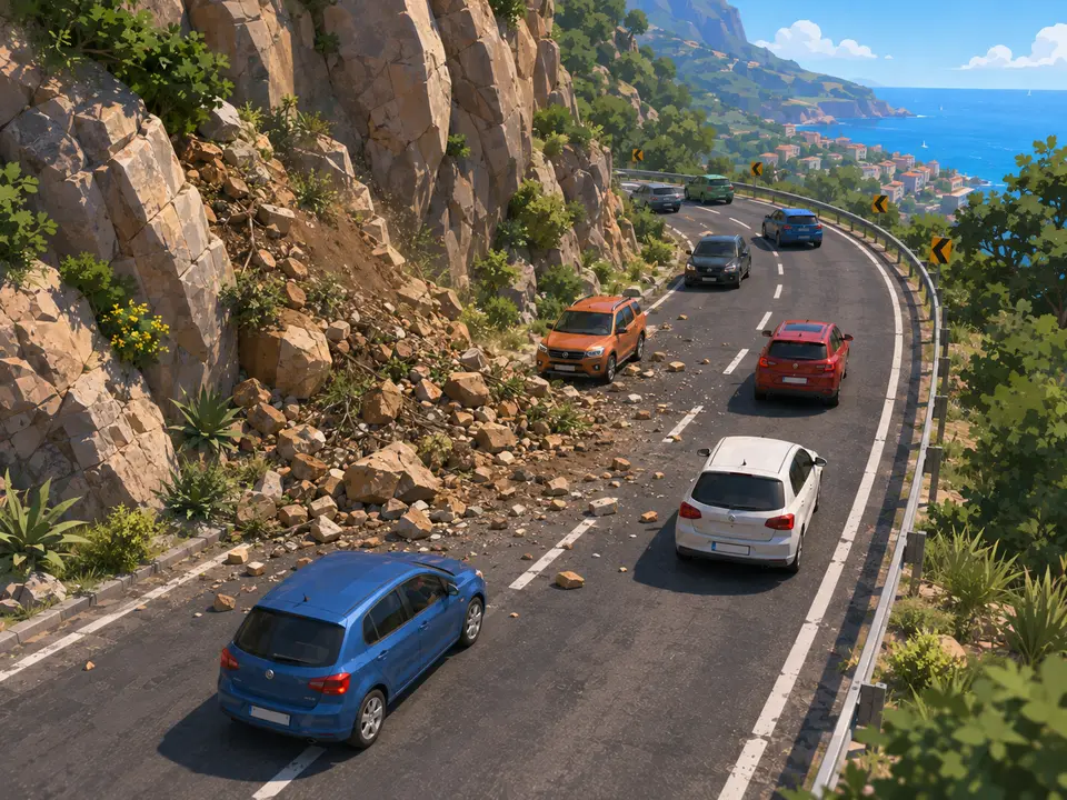
CAM-65Landslide onto the road
«Tell me if material comes down from the slope onto the road, and show me if the slope looks different from the last inspection.»
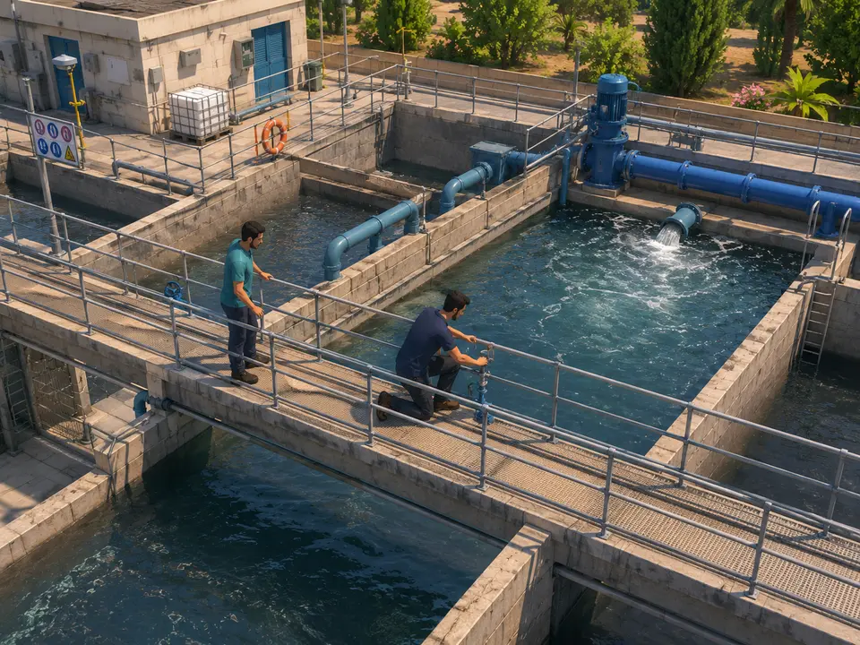
CAM-413No hard hat, no hi-vis, right at the edge of the open tank
«Tell me if anyone works at the edge of a basin without a hard hat or a vest.»
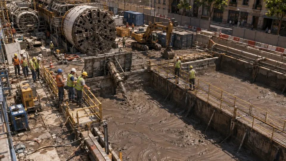
CAM-58The slurry pit close to the brim
«Tell me when the slurry gets within a hand's width of the top of the pit, before it goes over and I find it all over the site.»
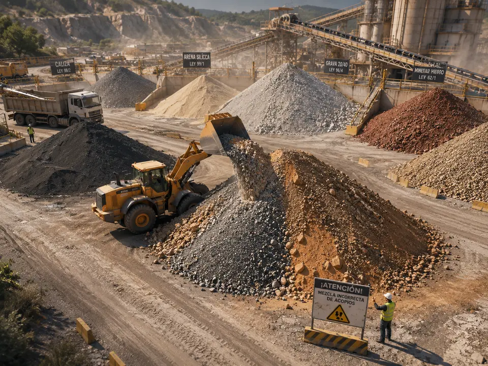
CAM-383A bucket of grey gravel on top of the wrong stockpile
«Tell me if a loader drops material on a stockpile that is not that pile’s material.»
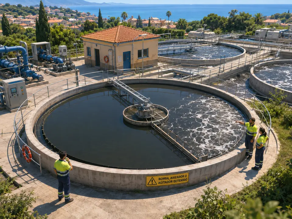
CAM-407Half the basin is moving and the other half is not
«Tell me if the surface of a basin stops moving while the system says the machine is running.»
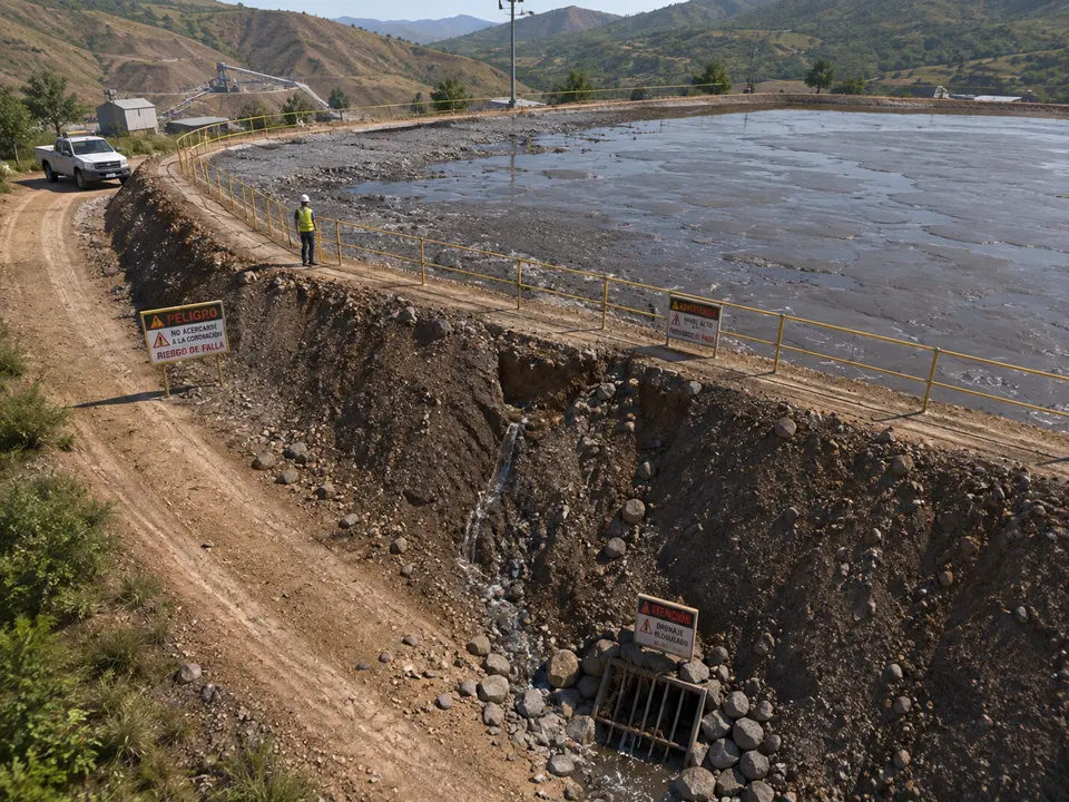
CAM-396Seepage cutting a gully down the tailings dam face
«Warn me if water appears on the outer face, if the gully grows or if the slurry gets close to the crest, and show me yesterday's image next to it.»


What it does not do
IRIS does not measure displacement and does not replace instrumentation. Piezometers, inclinometers and survey work measure what a camera cannot, and they are what governs the safety of a pond.
Nor does it say whether a slope is going to fail. It says that today it looks different from yesterday, and where. And it cannot see below ground, which is where almost every real failure begins.
Questions
- Does this replace the instrumentation on the pond?
- No, and that matters. Piezometers, inclinometers and survey work measure things a camera cannot, and they are what governs the safety of a pond. What IRIS adds is continuity: it looks at the surface every day, including the days with no inspection due, and speaks up when water appears where there was none or when something has moved. It is the eye between six in the evening and seven in the morning, when there is nobody up there.
- How does it know the gully has grown?
- Because it compares the same camera with itself. The framing does not move, so today’s image and last week’s can be laid over one another and the mismatch shows. IRIS marks the area that has changed and shows you both. It does not give you centimetres: it gives you the place and the date it started. The millimetre remains the surveyor’s job, and that is exactly the line between what can be claimed here and what cannot.
- What about at night, or in dust and haze?
- At night you see little, and with dust in the air you see less. We are not going to dress that up. For this word it matters less than for others, because a slope does not change in an hour: the useful comparison is one day against another, and one stretch of good light a day is enough. What you do have to do when setting it up is pick that stretch and always compare at the same hour, so a shadow does not look like a new gully.
- Does it work for stockpiles and road cuttings, or only for ponds?
- It works for anything that is a mass of material with a shape that ought to hold. A tailings pond, a stack of bales, a gravel pile, a road cutting, a slurry pond on a building site. The question is always the same: is this the way it was? What changes from one place to another are the marks you paint on the image and who receives the alert: on a site it is the safety manager, on a road it is the control room, because what lies underneath is a lane with cars in it.
The real interface, step by step
You set the rule once. IRIS applies it every time.
You will see a summary of the interface, played step by step and hands-free. Each round starts with another case. The complete tool does not fit in a demo.
- The rule gets built
- It goes to every camera
- Published, it watches alone
- And then it fires
Not seeing yours here?
These words are the ones we have built, not the ones IRIS understands. The list falls short on purpose: you ask for it in a sentence, and sentences do not run out. Tell us what is in front of your cameras and we will tell you whether it understands it, or not yet.
And the best part
“The white van, Tuesday afternoon.”That is enough to find it.
You type it the way you would tell a colleague, and the matching minutes come back, each with its camera and its time. You do not need to remember the exact moment.
Tell us your problem and we will say whether IRIS understands it, or not yet.
We reply the same working day.